2023.09.15
CTI Engineering Co., Ltd. has started providing technical services that consider its dam utilization priority map, which maps out the effects of utilizing water supply dams for flood control.
Technology & Research
We have created a dam utilization priority map, which maps out the effects of utilizing water supply dams--which are currently not expected to have any flood control effects--for flood control. This map shows river basins for which rapid development is necessary and for which utilizing water supply dams for flood control could have a major effect, and we are using the map to start providing new services, including evaluating the priority of dam utilization as river basin disaster resilience and sustainability measures.
1. Background
There are more than 1,800 water supply dams* throughout Japan that do not have flood-control functions. If these dams can be effectively utilized during abnormal floods, downstream river damage can be reduced.
Because the water storage capacities and discharge functions of individual dams differ, it would not be efficient to simply add flood-control functions to every water supply dam for use during abnormal floods. Instead, it is necessary to first add such functions to the dams that would have the greatest flood-control effect.
(* Water supply dam: a hydroelectric dam, agricultural water dam, or other dams outside the jurisdiction of the Ministry of Land, Infrastructure, Transport and Tourism)
2. Creating a dam utilization priority map
Our dam utilization priority map is the result of mapping out the evaluation indicator α, a ratio found by dividing ② by ① assuming the following definitions: ① the rainfall storage capacity of dams for each first-class drainage system river basin in Japan, ② the maximum amount of rainfall assumed in the case of the maximum possible flood at each river basin. (See Figure 1.) The larger the α ratio becomes, the more effective the utilization of the water supply dam for the corresponding river basin would be.
3. Providing a service for evaluating the priority of dam utilization as river basin disaster resilience and sustainability measures
We have also started providing technical services that include using our newly created dam utilization priority map to select water supply dams that would be highly effective if used for flood control as well as ranking river basins in order of which ones require early development. Specific service examples are provided below.
① Considering river basin disaster resilience and sustainability measures by combining the utilization of flood retarding basins, paddy field storage, and other measures with the utilization of water supply dams for flood control
② Considering dam operations aimed at gaining a real-time understanding of dam storage capacities--including predicted rainfall--and maximizing the utilization of dam functions accordingly
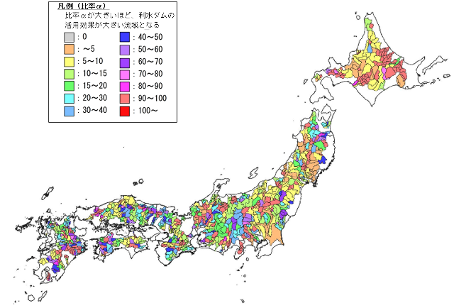
Figure 1. Dam utilization priority map of river basins for which the use of water supply dams, etc. for flood control would have a major effect (109 drainage systems/river basins throughout Japan)
Related papers: BASIN-SCALE ASSESSMENT OF RESERVOIR STORAGE VOLUME FOR FLOOD RISK REDUCTION (Advances in River Engineering, volume 28, 2022)
Research on Methods for Considering River Basin Flood Control Policies Based on a Comprehensive Evaluation of Drainage System Storage Capacities (Japan Society for Natural Disaster Science , under submission) Etc.
4. Future prospects
By providing technical services based on our dam utilization priority map, we will contribute to the more effective promotion of river basin disaster resilience and sustainability measures starting with the utilization of water supply dams.