2024.07.23
Developing a flood risk prediction DX technology using an AI model and game engine: Aiming for expedited water disaster relief and personalized disaster preparedness
Technology & Research
Aimed at lowering the cost of rainfall prediction acquisition, sophisticating flood predictions, and ensuring complete evacuation of residents in the event of a flood, targeting rivers and dams, which have a smaller basin, CTI Engineering developed a predictive precipitation data acquisition from Web meteorological information, an AI model-driven predictive radar precipitation correction and heavy rain area search function, and a game engine-driven flood visualization technology. Through these technologies, we expect to improve the accuracy of flood risk prediction, accelerate emergency measures, and raise public awareness of the disaster preparedness in local residents.
1. Background
In recent years, various management entities are promoting river basin water control efforts as part of the measures for resilience against floods that occur with climate change. Introducing a system that supports the prediction of water level and the operation of dams is considered for medium-to-small rivers and smaller dams that are constructed on medium-to-small rivers.
At the same time, acquisition of necessary meteorological information incurs service charges, which is a serious brake on the introduction of such a system. Another issue in implementing water control efforts is that the small size of the river basin leads to a larger impact in the case when the actual rainfall deviates from the predicted precipitation area. Furthermore, risk indication by figures and graphs does not appropriately communicate the urgency of danger, which may be a problem in terms of the residents' evacuation.
2. Overview and features of the developed technologies
We developed three technologies: a predictive precipitation data acquisition from Web meteorological information, an AI model-driven predictive radar precipitation correction and heavy rain area search function, and a game engine-driven flood visualization technology.
● Predictive precipitation data acquisition from Web meteorological information
We extracted predicted precipitation values from predictive radar precipitation images that are provided online free of charge to build a system that economically and automatically acquires the average precipitation over the river basin (Fig. 1).
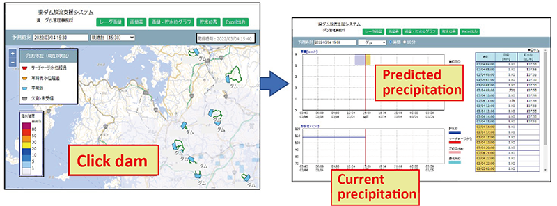
Fig. 1 Examples of the display of the river basin average precipitation automatic acquisition system
● AI model-driven predictive radar precipitation correction and heavy rain area search function
We corrected the intensity and spatial distribution of the predictive radar precipitation by using an AI model and developed a rainfall search function to capture the location of heavy rain (Fig. 2), which was previously difficult to reproduce completely. This function is expected to improve accuracy by about 20%.
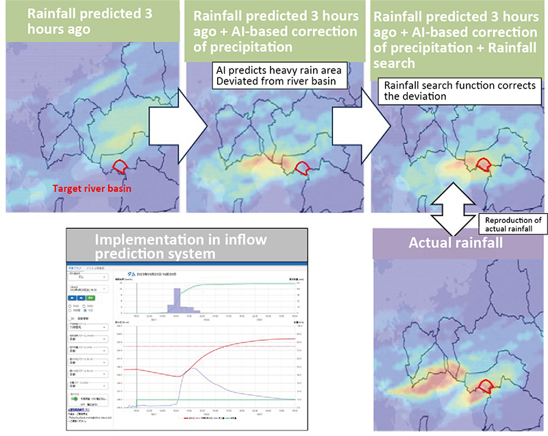
Fig. 2 Function that corrects predictive radar precipitation (AI-based correction and rainfall search)
● Game engine-driven flood visualization technology
We realistically reproduced the downstream river conditions, water level, and wave undulation based on prediction information by using the game engine 'Unity' and developed a visualization method that enables people to envision the sight and sound of disasters (Fig. 3).
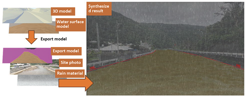
Fig. 3 Example of image output result that visualizes the prediction information (distributable as video)
3. Future outlook
We believe that being able to provide rainfall prediction data of medium-to-small rivers at affordable prices, accurately predict flood risks, and communicate the risk of flood damage to local residents and other relevant parties in an easy-to-understand manner will be conducive to improving future river basin water control and the residents' disaster preparedness awareness. CTI Engineering aims to further contribute to disaster preparedness around river basins using the DX technologies developed for flood prediction.