2025.01.15
CTI Engineering Co., Ltd. developed Dosha Kiji, a landslide hazard risk information system - Launch of a new information service to ensure that the danger of landslide disasters is not overlooked -
Technology & Research
CTI Engineering has developed Dosha Kiji, a landslide hazard risk information system, and launched a new information service for local governments and private companies that manage railways and roads to provide information on evacuation and preventive measures against landslides.
1. Background
Although local governments issue landslide warnings and evacuation orders, there continue to be many cases in which many people are injured or killed by these disasters. New information that more accurately conveys the urgency of landslides is needed to improve the effectiveness of resident evacuations and mitigate damage from landslide disasters that occur every year.
2. Technical Features of Dosha Kiji
- Reflects regional characteristics using AI technology to classify topographical and geological factors that differ from region to region
- Assessments consider all long-term and short-term rainfall characteristics based on rainfall data from previous disasters, without overlooking the danger of landslide disasters
- Provides easy-to-understand information on incremental hazard levels through comparisons with heavy rains that have caused disasters in the past
- Links with RisKma, a water-related disaster risk mapping system developed by CTI Engineering, enabling users to also view rainfall forecasts and related information such as the KIKIKURU Real-time Risk Map: Landslide published by the Japan Meteorological Agency on its website
- Simulator features based on rainfall from past disasters can be used in disaster drills, etc.
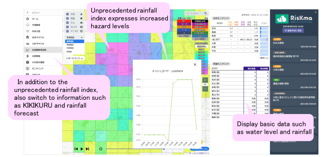
Overview of System Operation
*This system is based on the RisKma platform and can display hazard levels in any unit, such as a mesh or administrative boundaries on a map. It can also be used to check changes in hazard levels by displaying time series data.
3. Future Outlook
Going forward, we intend to promote the system to local governments and road/railway operators. We will also continue to collaborate with Kyoto University, which has provided us with academic guidance, to improve the system's functionality to meet more needs.