2025.10.15
The combination of drones and AI makes it easy to provide inspection support related to rivers, dams, erosion control (sabo), etc.
Technology & Research
1. Background
There has been an increasing need to use photography drones to handle patrol and inspection business at river, dam, erosion control, and other facilities. However, to inspect areas that are difficult to confirm by eye, it is necessary for the facility manager to sit in front of a monitor and continuously watch the video and to repeatedly review any spots that are overlooked, which takes a lot of time and effort.
However, we have developed a system that integrates autonomous drone flight, video filming, and disaster detection (AI) to save on labor related to and increase the sophistication of patrol and inspection business.
2. Developed technological features and details
- We have built a system that combines automatic flight, remote monitoring, and AI-based detection to facilitate work that includes all on-site patrol items, such as on-site attendance, confirmation, and decision-making. During our demonstration experiment, we tested our system at an erosion control site, where we took advantage of automatic flights to film the area, used AI-based image analysis to detect sediment runoff locations, and successfully discovered all the locations we set up before the test. Our system essentially enables the automation of regular patrols that have conventionally been done by people.
- By accumulating videos of past disasters as basic information for AI-based detection, we can work towards improved detection precision.
- Our system enables the measurement of the sediment runoff amount with accuracy within approximately 3% error. (Note that this is a reference value, and the actual accuracy depends on the filming environment.)
- This experiment was conducted at a mountain stream where the patrol and inspection work would have normally taken around two hours, but our technology reduced the necessary time to around 30 minutes. We therefore expect our system to be highly effective at facilities that, like this mountain stream, involve the patrol and inspection of many locations, which takes a lot of time.
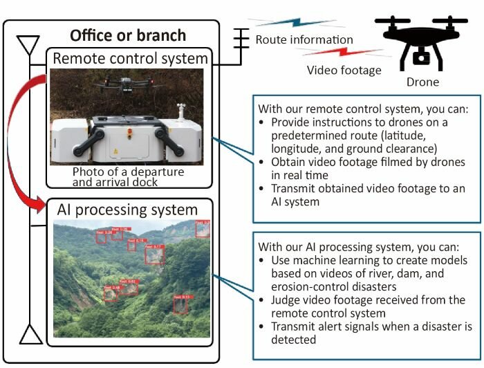
Conceptual diagram of our system, which combines drones and AI
With our remote control system, you can:
- Provide instructions to drones on a predetermined route (latitude, longitude, and ground clearance)
- Obtain video footage filmed by drones in real time
- Transmit obtained video footage to an AI system
With our AI processing system, you can:
- Use machine learning to create models based on videos of river, dam, and erosion-control disasters
- Judge video footage received from the remote control system
- Transmit alert signals when a disaster is detected
3. Future outlook
- By achieving various results related to erosion control, rivers, dams, etc., we will build remote monitoring systems that can be applied in a more diverse range of situations.
- Through AI-based disaster information learning, we will accumulate many videos to promote the ability to respond to a wide range of disasters.
- We are promoting preparations aimed at launching actual operations and services.