- TOP
- Project Introduction
PROJECT INTRODUCTION
-
Developing a Framework to Appropriately Prepare for Serious Damages Due to Heavy Rain
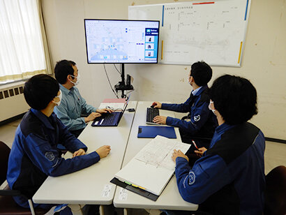
Heavy Rain Sewage Management System jointly developed with the city of Tomakomai The Sewerage Department Planning Section at the Tomakomai City Water and Sewerage Department handles a wide range of tasks including improvement projects for daily maintenance and management of the sewerage services, to medium and long-term improvement projects. With damage from torrential rains growing ever more serious in recent years, we worked with the city to develop the Heavy Rain Sewage Management System with the general-purpose cloud basin disaster prevention information OS RisKma at its core. This framework was designed to collect information on heavy rain and its effects more quickly and efficiently to facilitate the development of proper countermeasures. The system makes it possible to gather rainfall information and grasp its effects on sewerage facilities in real time and streamline patrols by local government staffers, significantly lightening administrative burdens. The Heavy Rain Sewage Management System with our general-purpose cloud basin disaster prevention information OS RisKma at its core was jointly developed and introduced with the city of Tomakomai to deal with a lack of technical staffers due to a dwindling birth rate and aging society, and serious damages due to heavy rain. It has been praised for streamlining tasks and lightening the workload of city staffers, winning the 15th Minister of Land, Infrastructure, Transport and Tourism Award (Junkan no michi Sewage System Award) in the Asset Management Division.
-
Building a Space to Connect the Town and River
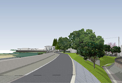
Shirakawa River Severe Disaster Countermeasures Special Emergency Project (Ryujin Bridge – Ozeki Bridge Section) The Shirakawa River Severe Disaster Countermeasures Special Emergency Project (Ryujin Bridge – Ozeki Bridge Section) is a river improvement project handled by the Kumamoto River and National Highway Office of the Kyushu Regional Development Bureau at the Ministry of Land, Infrastructure, Transport and Tourism. It covers the section of the Shirakawa River running from the source at Aso to the Ariake Sea through the urban area of Kumamoto City. Our involvement in the project covered the landscape review committee and meetings with residents as well as arrangements with the local government and designing a river structure that took into consideration the landscape and environment. This project not only involved ensuring the requisite water control functionality, but also minimizing the impact on the river environment, and creating a space that area residents could use on a daily basis. We also aimed to raise awareness of disasters by creating an environment where people could interact with the river daily. Specifically, development of the levee included not only water management, but also aimed to improve (1) migratory capabilities, (2) accessibility, (3) spatial diversity, (4) safety and peace of mind, while incorporating natural environment conservation elements, developing the overall landscape of the river, and resident ideas into our design. The project was the project won the Japan Institute of Design Promotion’s 2020 Good Design Award and the project won the Civil Engineering Design Prize 2022 (Grand Prize) sponsored by the Japan Society of Civil Engineers for its creation of building a space to connects the town and the river according to the location, and for its embankment development that enhances residents' awareness of disasters while enriching their daily lives.
-
Connecting Local Resident Ideas to the Future
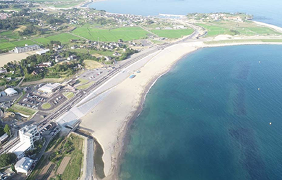
Oya Coastal Beach Revitalization and Urban Development Project The Oya coast (Kesennuma, Miyagi) was a beautiful section of beach with white sand and green pines and attracted over 60,000 visitors annually. It suffered massive damage in the Great East Japan Earthquake (75 dead, 946 buildings damaged [48% of the area]) however, and the beach, which was a symbol of the area, suffered a major setback due to the tsunami and subsidence across a wide area. Due to jurisdictional differences, the Oya coastal levee cannot be set back toward the land side of the area, so it was initially planned for installation on the beach. However, residents wanted to rebuild the beach, so they planned their own workshop, invited experts, and submitted a proposal of their ideal image of the area to the government. The government made arrangements with the Oya coast authorities and relevant government agencies, working with the locals while regrading the national route in order to move the levee further inland. For six years beginning in 2016, we were involved in the Oya coastal development project in design and orderer support. We kept the viewpoint of the government in mind, doing our best to incorporate as many of the requests from locals as possible in our designs and talking with locals and relevant organizations. We made various arrangements such as using the hinterlands and considering the landscape, rebuilding the beach, and providing orderer support after the design was completed. Our collaboration with locals during the project led to high praise from various parties, resulting in winning not only the 2nd Minister of Land, Infrastructure, Transport and Tourism Green Infrastructure Award (Disaster Prevention and Mitigation Division), but also the Japan Nature Conservation Award in 2017, and the Zenken Award in 2022.
-
Building a community that people will choose 100 years from now
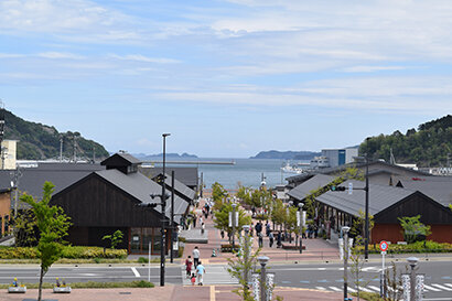
Onagawa Central District, Onagawa Earthquake Reconstruction Project We have been involved in the reconstruction of Onagawa Town since right after the Great East Japan Earthquake, which destroyed many of the town’s functions. One month after the disaster, the Onagawa Town Reconstruction Liaison Council developed as a private organization for considering the town’s future and local landscape. At the same time, the Onagawa Town Development Promotion Council was established as an organization to promote reconstruction and town development through the participation of local residents. Subsequently, the Onagawa Town Development Working Group (June 2012) and the Onagawa Town Reconstruction Town Development Design Conference (September 2013) were launched, through which the mayor, town hall staff, construction professionals, urban design experts, and town residents gathered to think about and discuss the utilization and design of the space. This project is the result of those meetings. The design concept of the Onagawa Central District, a symbolic space in front of Onagawa Station, was finalized as “a town that lives with a view of the sea.” Project members discussed how to create “an urban space that people will continue to choose 100 years from now” that harmonizes with the rich nature of the surrounding area. Renga Michi, the brick pathway that forms the backbone of the Onagawa Central District, is a pedestrian promenade that connects Onagawa Station to the sea (Onagawa Bay). It was designed as a belt-shaped park lined with different types of trees and benches of varying shapes to soften the axial view of the sea. We also designed the space to appear continuous with the sea by unifying spatial components such as the pavement, benches, plants, and lighting. We coordinated carefully with the designers of the buildings along the Renga Michi, harmonizing the design of the promenade with the buildings and decks to create a unified space with shared functions. This has created comfortable and attractive space in the town, which now serves as a place for relaxation and bustles with residents and tourists. In recognition of this achievement, the project won the Japan Institute of Design Promotion’s 2018 Good Design Award. We received positive feedback such as, “By visiting the space in person, one can sense the symbolic quality of the spatial design that is not only visual, but also experienced.” In addition, the following year, the project won the Civil Engineering Design Prize 2019 (Grand Prize) sponsored by the Japan Society of Civil Engineers. It was praised for the safe residential areas built on high ground and the compact urban area formed by various facilities constructed around the Renga Michi in front of Onagawa Station. The fact that urban development was conducted through cooperation between public and private sectors also received high praise, as did the landscape design itself.
-
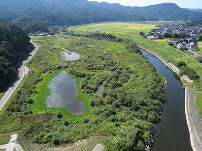
Rich wetlands that nurture life
Matsuura River (Class A River) Azame-no-se Nature Restoration Project Azame*-no-se is situated in the middle reaches of the Matsuura River, which flows through northern Saga Prefecture. It spans an area of about 6 hectares and is about 1,000 meters long and 400 meters wide. A strong levee has been built on the left bank of the river. On the other hand, there is no levee on the right bank, protecting the Azame-no-se area. This area was originally a paddy field that experienced habitual flooding every year. In 2001, the Law for the Promotion of Nature Restoration was enacted, and the River Bureau of the Ministry of Land, Infrastructure and Transport began to promote nature restoration projects. This is when the Azame-no-se Nature Restoration Project was first launched. As mentioned above, the Azame-no-se area was unprotected by levees, so the Bureau initially considered whether to construct a levee system as a flood control measure or to acquire the land. However, it was eventually decided to acquire the land and incorporate it into the river site as a retarding basin for continued maintenance and management. Whenever the river level rises, the land becomes submerged in water. This, however, is the most distinctive feature of the area and a key element of natural regeneration. The goals of the project were “restoration of floodplain wetlands” and “restoration of connections between people and living things.” The former, in particular, is appropriate for a nature restoration project, which “is realized based on requests from the community and upon thorough discussion, while invigorating the community.” The floodplain ecosystem appears to be randomly shaped when viewed in aerial photos alongside geometrical channels, ponds, and terraced fields. However, it is designed in a meaningful way, including those parts of it that are underground. The ecosystem is formed by the movement and diffusion of floodwater, sediment, nutrients, organic matter, and organisms from rivers due to floods. In other words, flood frequency and disturbance are important in floodplains. When the river floods, fish escape into creeks to spawn, and their offspring return to the river as fry. We set up multiple ponds to allow different levels of access to people, including a pond with the largest variety of dragonflies in the prefecture, and aimed to restore the original satoyama environment with terraced paddies and waterways. We incorporated the concept of adaptive development into the design process, which allowed us to make hypotheses, verify their effectiveness, and make modifications to the construction work. At first, we struggled to control the overgrowth of invasive plants. However, thanks to the maintenance and management of the area, including community volunteer activities, children’s rice planting, and natural environment surveys, the nature in the floodplain has become richer year after year. In this project, we were mainly responsible for studying the approach for achieving the goals of the floodplain wetlands; studying and implementing the design of various areas in the floodplain, such as the terraces, reservoirs, and creeks; monitoring the environment during and after construction; and compiling the official construction records. In 2007, the project won the Civil Engineering Environment Prize sponsored by the Japan Society of Civil Engineers. In 2017, ten years after the project was completed, it won the Civil Engineering Design Prize 2017 (Grand Prize). *Azame is a regional variation of the word azami, or thistle flower. It is said that many of them grew wild here in the past.
-
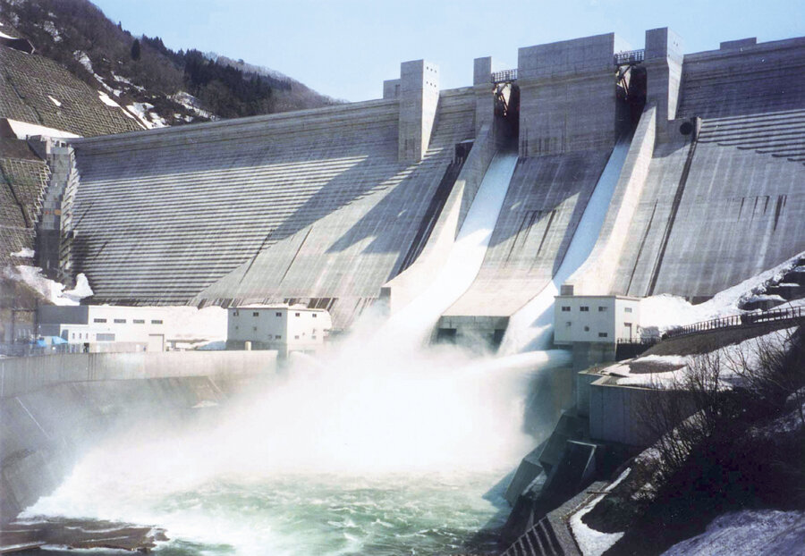
Technology used for the first time in a dam managed by the MLIT
Gassan Dam Flood Control Project, Tsuruoka City The Gassan Dam was constructed on the Bonji River of the Akagawa River system, a Class A river in Tsuruoka City, Yamagata Prefecture. Rivers in the Akagawa River system have a swift flow in the upper reaches, and a gentler flow in the lower reaches. Historically, they have been subject to repeated flooding in the middle and lower reaches. Improvements were made to rivers in the Akagawa River system in 1917 to counter these floods, but the flooding did not subside. Therefore, the Gassan Dam was planned as part of a subsequent flood control project. It is a 123-meter-high concrete gravity dam. The project was completed in 2001 with the aim of securing a stable water supply for the southern part of the Shonai region, including Tsuruoka City, which at that time used groundwater as its water source. It was also intended to control floods, maintain a regular river flow, and generate power. The name of the lake formed by the dam is Asahi Gassan Lake. The Goddess of the Moon by Yutaka Kato, a sculptor from Shizuoka City, watches over the Gassan Dam from the Asahi Gassan Lake Observation Deck, where visitors can enjoy a panoramic view of the lake. Visitors are allowed to tour the inside of the dam, including the inspection gallery. Those who wish to join a tour should apply at the Gassan Dam Management Office. The Gassan Dam Regional Disaster Prevention Center, located on the south side of the dam, also has an exhibit that introduces the Gassan Dam’s flood prevention function. CTI Engineering actively used precast formwork in the design of the main body of the dam. In the construction plan and design of the facility, we proposed the use of the Roller Compacted Dam (RCD) method, a streamlined construction method for the placing of concrete for the dam structure, as well as a belt conveyor system to transport the concrete. This system was adopted for the first time in a dam directly managed by the MLIT. Until 2012, after the transition from construction to management, we were engaged as a “dam doctor” to assess the stability of dam through various dam behaviors, checking the seismographs, plumb lines, pumping pressure, leakage volume, displacement, distortion, and other factors indispensable for the management of the dam.
-
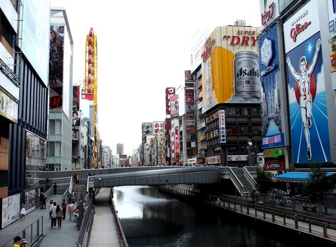
That famous bridge in Osaka that draws tourists
Osaka City Ebisu Bridge Replacement Project The Ebisu Bridge is a famous tourist spot in Osaka. The meaning behind its name is “a bridge to the Ebisu Shrine in Imamiya Village (Imamiya Ebisu Shrine).” Since the bridge was built, it has been repaired and replaced 13 times. In 1878, the bridge was converted into a steel bridge, and in 1925, into a reinforced concrete arch bridge. The current bridge was completed in 2007. It was planned as part of the Dotonbori Riverfront Development Project under the theme “Aquapolis Osaka,” and a design competition was held with Japanese and international applicants. The winning design, which conceived of the bridge as the “navel” of Osaka’s Minami (south) area, became the basis for the new bridge. Today, the bridge is a major tourist attraction located in the center of Dotonbori. It provides a view of the huge neon signboard of the Glico running man, the Don Quijote Ferris wheel, and other landmarks that make Osaka’s Namba area immediately recognizable. The Ebisu Bridge also serves to connect the Shinsaibashi and Ebisubashi shopping districts. Tourists who visit Dotonbori typically enjoy various foods and drinks in the area as they walk toward Ebisu Bridge. After that, they enjoy shopping in the shopping districts and take photos at Ebisu Bridge to mark their visit. Ebisu Bridge was due to be replaced because of the aging of the bridge structure and the need for measures to discourage people from jumping off the bridge. CTI Engineering was responsible for the detailed design. We faithfully reproduced the bridge’s circle-shaped slope and the LED lighting on the surface of the water, while ensuring the safety of pedestrian traffic and connectivity to the boardwalk. The new Ebisu Bridge has been designed to create a dramatic effect with a circular public space on the bridge, while incorporating a slope along the edges of this space that allows people to enjoy changes in the scenery as they descend toward the riverfront.
-
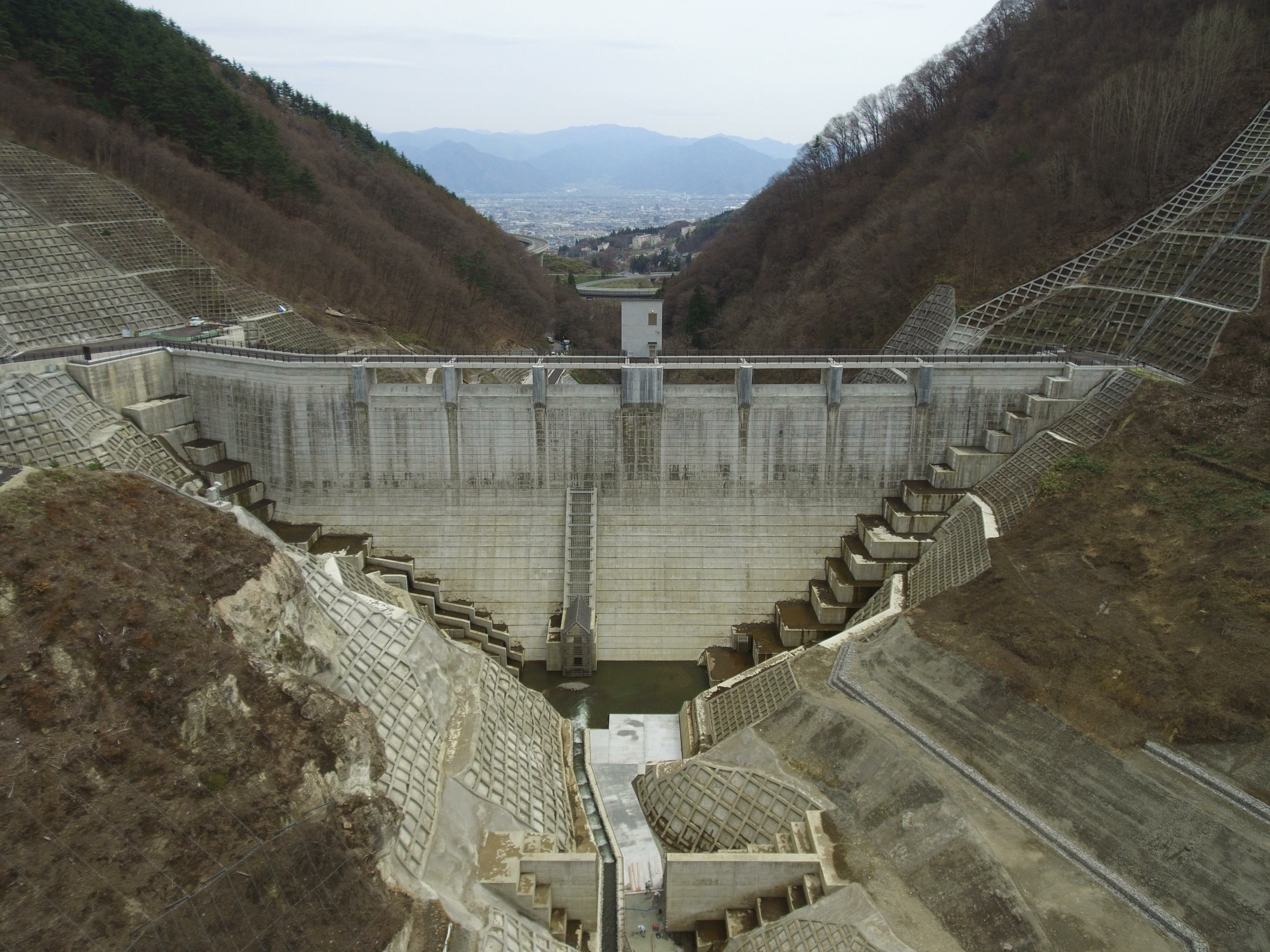
An environmentally friendly flood control dam that does not store water
Asakawa Dam Project, Nagano City The Asakawa Dam was constructed on the Asakawa River of the Shinano River system, a Class A river with a length of about 20 kilometers originating from Mt. Iizuna in northern Nagano City. The Asakawa River flows through a newly developed urban area of Nagano City, joining with the Chikuma River. Although it is a medium to small sized river, the flow is steep, and floods have been frequent. For this reason, the dam was completed in 2017 as a dedicated flood control dam operated by Nagano Prefecture. It is a 53-meter-high flow-through concrete gravity dam. However, there were twists and turns in the events leading up to the construction of the Asakawa Dam. In February 2001, the then-governor of Nagano Prefecture, Yasuo Tanaka, launched a declaration of “No More Dams.” Subsequently, in June 2002, the prefectural assembly announced that they would be suspending construction of the Asakawa Dam. They conducted a study that targeted not only the Asakawa Dam, but also the Kiyokawa Flood Control Dam, the Kakuma Dam, and the Kurosawa Dam in the Shinano River system. All of them—except the Asakawa Dam—have been suspended. Although the administration studied flood control measures for the Asakawa River that do not rely on dams, including the use of in the river channel, they ultimately changed direction and put forth a policy that included the construction of dams as a flood control measure. After that, a flood control plan that combined the use of a dedicated flood control dam and river improvements was adopted, and construction of the Asakawa Dam began at last in May 2010. This time, CTI Engineering was responsible for a wide range of fields, including geological analysis of the surrounding area, reservoir landslide countermeasures, environmental surveys, schematic and detailed designs of the dam itself, and construction planning. Since water is not normally stored in the dam, it does not interfere with the flow of sediment or fish runs, and there is no deterioration of water quality due to . The opening in the dam, called the “principal spillway,” is equipped with a stair-like fish ladder for fish to run up. For this reason, the Asakawa Dam is sometimes referred to as a flow-through dam or “perforated dam.” On the other hand, in the event of a flood, it will start storing water and prevent damage downstream. Because of these features, the Asakawa Dam is said to be an “environmentally friendly dam.”
-
World's first compound bridge, winner of the Tanaka Award
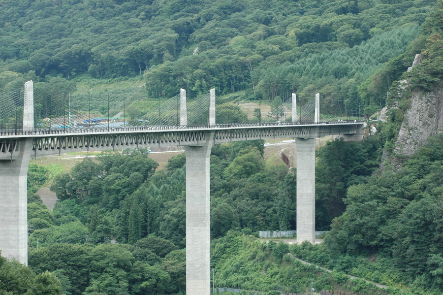
Naganohara Town Fudo Ohashi Bridge Project The 590-meter-long Fudo Ohashi Bridge spans Lake Yamba-Agatsuma in Naganohara Town. When construction began in March 2004, it was the world’s first PC compound truss extradosed bridge. In 2009, Prime Minister Yukio Hatoyama’s Cabinet announced that the construction of the Yamba Dam would be halted, and it was portrayed by the mass media as nothing more than a symbolic facility. However, construction of the bridge, which was intended to be a substitute road as part of the Yamba Dam Project, went ahead as planned. Not only did Gunma Prefecture indicate that it would continue the project, but the national government also announced that it would continue the project as part of a Livelihood Reconstruction Project, after considering the results of a resident attitude survey conducted in 2010. CTI Engineering was in charge of the design at this time. The name of the bridge during its construction was the “Lake No. 2 Bridge,” but it was subsequently named the Fudo Ohashi Bridge in 2010, after the nearby famous Fudo Falls. The project was scheduled to be completed in 2011, but it was postponed due to the Great East Japan Earthquake that occurred in March of the same year. The Fudo Ohashi Bridge was awarded the 2010 Tanaka Award, presented by the Japan Society of Civil Engineers, for its significant contribution to the development of composite structure technology in bridge construction. The bridge integrates the structural technology of PC compound truss bridges, which are characterized by their light weight and great appearance, and extradosed bridges, which reduce the use of materials and enable cost reductions. Incidentally, the fusion of PC compound truss and extradosed bridge technologies has resulted in the smallest girder height (6 meters) and the longest span (155 meters) of any PC compound truss bridge in Japan.
-
Yodo River, Yodo River system (Osaka City, Osaka Prefecture)
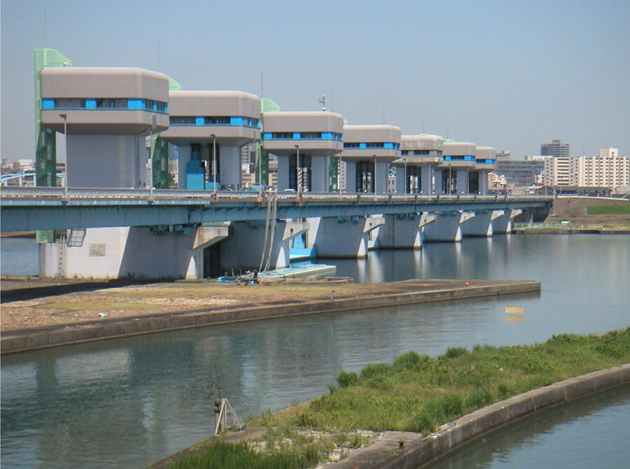
Osaka City Yodogawa Ozeki Project The Yodo River is the only river that flows from Lake Biwa into Osaka Bay. Built in 1983, the Yodogawa Ozeki is a weir located at the downstream end of the river. The water quality of rivers in Osaka City had deteriorated due to delays in sewerage system development caused by Osaka’s rapid population growth. The weir was built to improve the situation of this so-called “sewage canal.” This time, CTI Engineering was in charge of the main body design and construction plan for the Yodogawa Ozeki. In fiscal 2004, we were also in charge of the maintenance and management of the weir, including the design of seismic and anti-tsunami reinforcements. The Yodogawa Ozeki is one of the largest tidal and diversion weirs in Japan, with a span of 668 meters (the distance between the supporting members of the bridge structure) and a retractable gate to control the water level. It is jointly managed by the Kinki Regional Development Bureau of the Ministry of Land, Infrastructure, Transport and Tourism and the Japan Water Agency for the purpose of supplying water and industrial-use water to Osaka and Hyogo prefectures. The weir’s current purpose is to supply water for domestic, industrial, and sewage use to Osaka and Hyogo prefectures. It supplies water, sewage, and industrial water at a rate of 20 tonnes per second. On the other hand, it releases water for unspecified use into Osaka Bay at a rate of 100 tonnes/second at high tide and 40 tonnes/second at low tide while making adjustments. The Yodogawa Ozeki is also capable of handling flush discharges, which are artificial floods triggered by water volume control measures in order to improve water quality by flushing polluted water into Osaka Bay.